Pages

Sunday, June 29, 2014

Little-Old-Lady Rides Again

(by Tony) Same course as yesterday, but odometer registered .05mi less -- must be riding straighter lines. Cadence, (avg 65rpm,) definitely needs work!

Weather: 90°F, mostly sunny, still, a bit more humid
Terrain: rolling, some shade
Distance: 6.3mi
Speed: (avg) 11.9mph; (max) 34.6mph;
Avg Cadence: 65rpm

Saturday, June 28, 2014

A Bearded Little-Old-Lady on his Bicycle

(by Tony) Struck off with greater confidence today. Both legs felt pretty good, though hills are still a challenge, and I still find myself, at times, pedaling in squares, and hitting the chainstay with my affected foot. Did remember how to reset my cyclocomputer, so I did get some stats today:

Weather: 88°F, mostly clear, no wind, dry
Terrain: Rolling, some shade
Distance: 6.4mi
Speed: 11.5mph (I know - little-old-lady pace - but it's what I can do.)

A BEARDED little-old-lady on his bicycle

Sunday, June 22, 2014

First Post-Stroke Bike Ride

Got my bicycle out of mothballs for the first time since my stroke last July.  Short hilly ride -- 6 mi -- no stats; didn't remember how to reset my cyclocomputer. Bike performed  flawlessly, (once I put the chain back on,) and my body seemed to do what it was supposed to. My post-stroke balance problems did not seem to affect my riding much, although I did wobble some under 4mph, and I was not as precise on my lines at any speed. Took it easy, and felt pretty good, for the most part. My left-side weakness manifested itself mainly in difficulty maintaining a cadence above 88 rpm without losing rhythm, and a tendency to toe out with my left foot, such that my left heel frequently hit the chainstay. All in all though, I'm pretty happy with this ride, and feel encouraged for the future. 

Saturday, April 12, 2014

Hike through Devastation

Hike through Devastation - 2014 - our first hike of the year was an upsetting walk through the devastation being perpetrated on the once cool, quiet and comforting kingdom teeming with forest life that was the Hemlock forest of Kenoza Lake.

Came around the bend along the shore of the Lake and were startled by this scene of devastation.


We are told all these trees were "buggy". I believe the name of the "bug" is $$$perboardfoot.


It's hard to imagine that this kind of devastation was allowed in the name of "timber management"


Judy expressed it much more eloquently in her facebook post than I can ever hope to:
"Let me tell you...I grew up on a federally registered tree farm, doing forestry improvement. I was wielding my first saw at the age of 5. I worked for the United States Forest Service in the White Mountains of NH, doing timber management and forestry improvement on the federal level."

"I can honestly say, without hesitation or reservation that what they have done at the Winnekenni Park, and what they are doing is a travesty, and obscene. There is no way that they were interested in forestry improvement in any way shape or form. There has been NO respect shown for the forest or the land. The forest is gone, utterly denuded save the dripping, bleeding stumps that are trying to nourish trees that no longer exists. The sap, the life's blood dripping down and running into the dirt. The trees don;t even know they're dead yet. I felt like throwing up. I wept for them, and there are so many blue stripes painted on many more trees...this is the mark of death, the paint marks the next victims to fall. It was said that the trees were all buggy...what I sense is the $$ signs the powers that be saw in the board feet of lumber now coming out of that once magical place."
There are several acres so stripped, and many more slated for the same treatment. We both left that "once magical place" grieving today.

Please visit our Hike Through Devastation Gallery for more photos and comments.

Tuesday, October 15, 2013

Hiking Mt Agamenticus

We were looking for a good introductory hike with a little climbing to rehab from my stroke. We saw a TV program about Mt Agamenticus, and it looked like it would fill the bill - short, (2.2 mi round trip by the "Turtle Loop",) a little climbing, (692 ft,) but no hand-over-hand, and facilities at the summit!

Mt Agamenticus is an easy drive off Rte 95 in York, Maine. There are numerous parking areas along the summit road. We parked at the bottom and started up the Ring trail and followed it in a clockwise direction to the Witch Hazel trail that leads to the summit.


The "Turtle Loop" is a relatively easy interpretive loop with some more or less gentle ups and downs and some rocky and rooty areas, especially where it steepens. All trails are very well marked.

Judy reads one of the many descriptions of flora and fauna lining the Turtle Loop


Here and there we were treated to a glimpse of the scenic vista that was to come.

On the Ring trail: a glimpse down a stream bed to the White Mountains

On the Witch Hazel trail leading to the summit, the going gets a little steeper and more rugged, but not bad at all.


The summit of Mt Agamenticus is mostly treeless, but a great variety of grasses and shrubs grow exuberantly between the rocky outcroppings. It has more the look of a post-glacial meadow than a wild and woolly mountaintop.

out of the woods, and onto the summit


And, (How civilized can you get?) a lodge at the top! not to mention porta-potties and picnic tables. 


We had a nice picnic at one of the tables and enjoyed the view.  Afterwards, I walked around the summit perimeter and took some pictures. There are also two viewing stands on the summit, affording a spectacular 360° view -- to the east, the Atlantic ocean, Cape Neddick, and even Cape Ann, and to the west, the White Mountains.

Looking Northwesterly toward the White Mountains

 Looking East to the Atlantic Ocean
Cape Neddick just behind the right branch of the tree, and Cape Ann off in the distance on the right.


Looking West to the White Mountains


View of the White Mountains from below Vulture's View


We went back down the Witch Hazel trail, and took the Ring trail down the East side of the mountain.  It seemed a little steeper and a bit more rugged than the trip up, but, again, not bad. We did get briefly lost when the Ring trail seemed to end at the summit road.  After going out on the summit road and not finding the continuation of the trail, we discovered that the trail actually took a hard left as it touched the road, and we continued on our way. 

All in all a very enjoyable hike and some spectacular scenery were just what the doctor ordered.

Friday, August 30, 2013

A Hike for Rehab

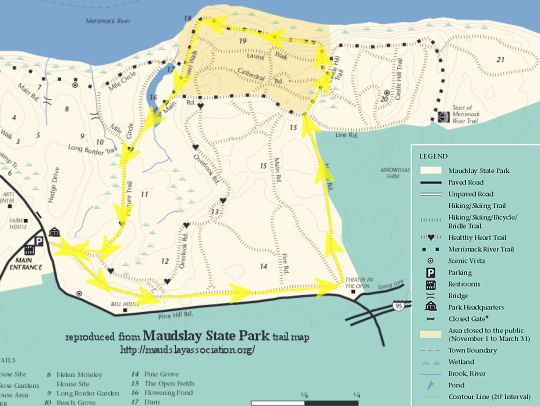
Well, it's been awhile.  The summer has passed with no hiking or biking to write about.  On July 8, I suffered a stroke while undergoing a cardiac stent operation.  I was lucky.  It was a mild stroke, and, although my strength, coordination and mobility were compromised, I was able to move my left arm and leg.  I spent two weeks in a rehab hospital, and have spent the rest of the summer rehabbing at home and outpatient.  Much of my rehab was a walking program to develop strength, coordination and balance.  I was finally able to do a little hike at Maudslay State Park last weekend, and again Tuesday.  Did a couple of miles with hiking poles.  Tuesday I felt more confident on the downhills and over roots and uneven ground.  Things are looking good!

enable images

The trails at Maudslay are lovely.  The terrain is easy - gently rolling - with few bumpy parts.  Scenery is also lovely.  A wonderful place to take a rehab hike.  Will be going there every chance I get for the next few weeks.

Sunday, June 23, 2013

2013 Shakedown Hike

Took a nice hike this morning at Winnekenni Castle, around the perimeter of Kenoza Lake -- about 3.5 miles, 78°F, Hazy, 1.5 hrs -- that served as shakedown for my new hiking boots.

My previous boots were LL Bean Knife-Edge, a top-quality hiker of the time, (17 years ago.) They were rugged, dependable hikers, but a little narrow for me. I take a 4E width, and the LL Bean hikers only come in D or EE. This past winter I dropped a log and smashed the big toe of my left foot, and the 4E width became a pressing necessity, (excuse the pun.) Finding serious hiking boots in 4E width is not easy. I came across the Propét Cliff Walker hikers, which are available in 3E and 5E width. The price seemed pretty reasonable, and the reviews were pretty positive, so I ordered a pair. Reviewers said they run large, so I ordered a half-size down in 5E. Got them this past week. They are definitely a notch or two below the LL Beans in quality and apparent ruggedness -- The leather is a cheaper, more open-grained leather, and very thin -- but they are wonderfully comfortable, and give decent support.  They performed admirably on this shakedown hike. Longevity remains to be seen.

Anyway, Winnekenni and Kenoza Lake were beautiful...

Winnekenni - Kenoza Lake - 2013
Winnekenni Castle - Kenoza Lake - on the Dudley-Porter Trail

...and my feet were very happy!
:)